UrbanVLA

TL;DR
we propose UrbanVLA, a route-conditioned VLA framework designed for scalable urban navigation.
Motivations
- T raTra
Approach
Model
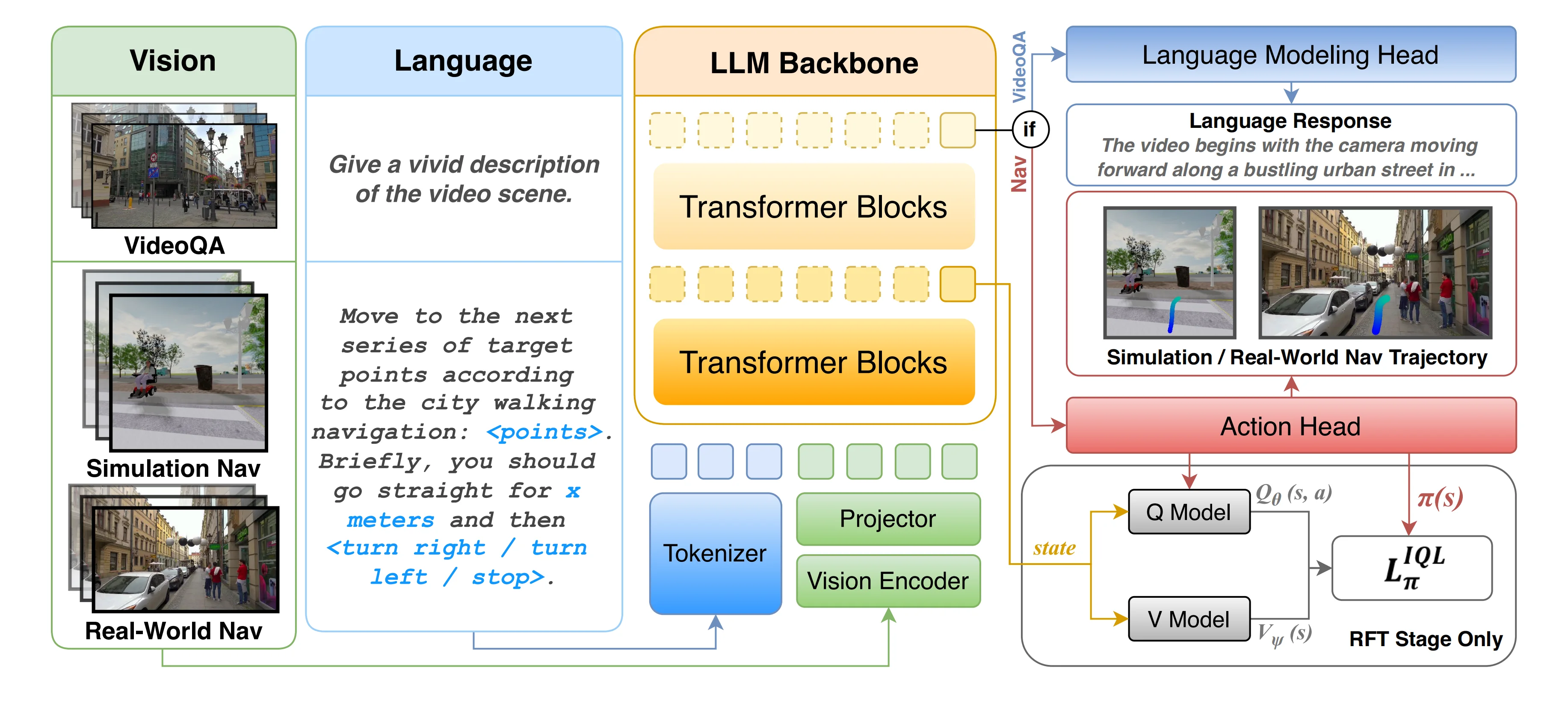
Base Model: NavFoM
- 通用导航基座模型 (cross-embodiment)
- vs UrbanVLA: Urban Micromobility
Base Model: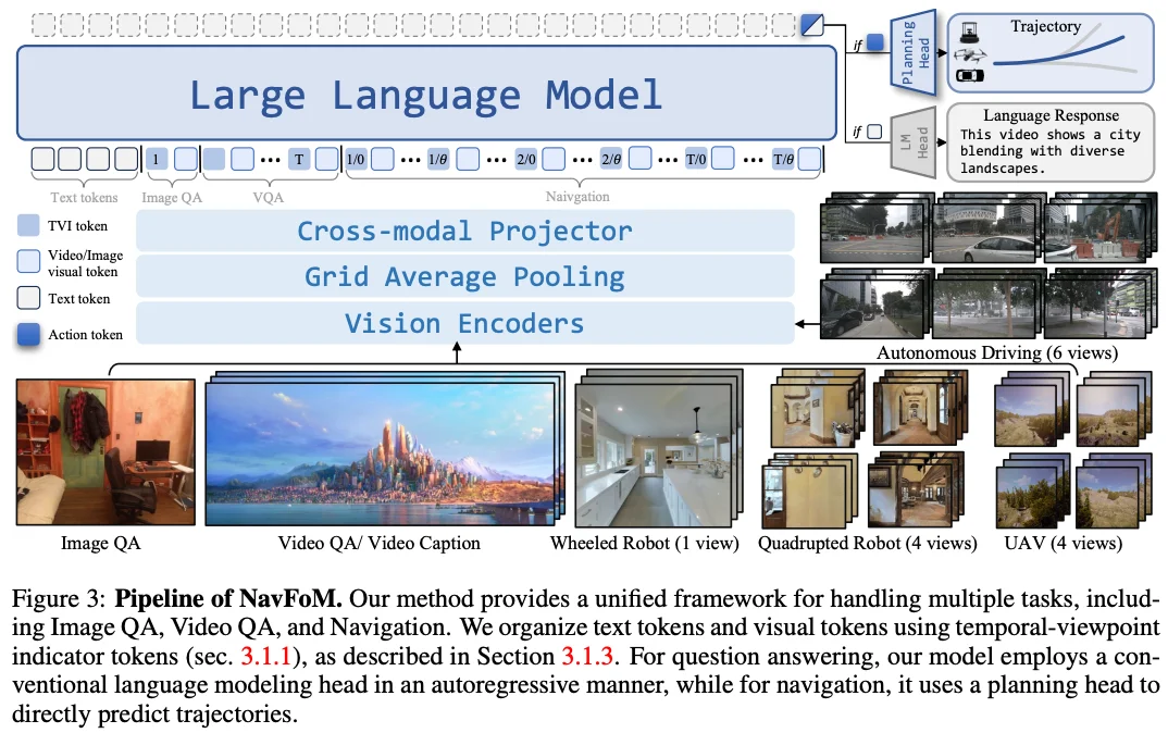
Input
- temporla multi-view images
- high-level roadbook instructions: high-level target route formulated by a sequence of 2D coordinates (waypoints) sampleed from the target route under the current egocentric frame.
Output
- Navigation tasks: capture the generated action token at the current time step and decode it through an MLP-based action model to obtain the navigation trajectory (waypoints under the current egocentric frame).
- VideoQA tasks: autogressively generates a set of language tokens, which are then decoded through the language model head.
Vision Encoder
- pre-trained DINOv2: 纯视觉自监督模型,细粒度图像特征
- pre-trained SigLIP: 图文对比学习模型,图像和文本对齐的语义信息
- concatenate in the channel dimension
Vision-Language Adapter
grid pooling (减少token 数量) -> two MLPs (减少 token 特征长度)
LLM backbone
pre-trained Qwen2
High-level Route Prompt Template
apply a prompt template to encode high-level roadbook instructions into text.
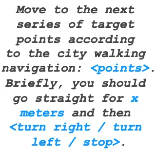
How to Design the Prompt Template?: Given a high-level navigation route:
- resample the upcoming 40m of the route trajectory at a distance of 2m -> resulting in 20 waypoints
- convert them into the robot frame. -> a set of waypoints sampled from the high-level route provides the agent with the overall geometry and orientation of the forthcoming path.
- -> distance and direction instructions for the next turn (for example, ‘turn right in 30 meters’) convey essential information to transition between blocks, a critical scenario for successful urban navigation.
- when training, we apply a corner detection algorithm to segment the route into blocks and then derive block-level distance and direction cues from these segments
- when real-world inference, this information can bu directly acquired from the API of the city navigation tool.
- formulate the above information into an instruction template -> obtain the navigation instruction.
Why do we design the prompt template like this?:
- can be interpretable by VLA models.
- aligned with the data schema of the prevalent urban navigation tools (e.g., Amap).
Training Recipe
Supervised Fine-tuning (SFT)
learns essential urban navigation capabilities such as goal-reaching, collision avoidance, and social compliance.
- route-conditionednavigation task: using trajectories from the MetaUrban simulator and Sekai web navigation videos.
- Sekai-Real(来自 YouTube 的 walking / drone videos)里的 camera trajectories,是它们自己用结构恢复/相机追踪方法从视频里提取出来的;Sekai 论文写得很明确:他们对 Sekai-Real 使用了 state-of-the-art SfM 流程来提取 camera trajectories,并在多种方案里最终选了 MegaSaM 作为基线方法来做轨迹标注与优化。
- real-world VideoQA task: to enhance real-world scene understanding.
- LongVU:https://vision-cair.github.io/LongVU/
- Sekai:https://lixsp11.github.io/sekai-project/
Reinforcement Fine-tuning (RFT)
offline reinforcement fine-tuning on a sim-real aggregated dataset.
particularly in collision avoidance and handling ambiguous cues, we adopt an offline RL approach based on Implicit Q-Learning (IQL) [27], which is well suited for offline data and mitigates out-of-distribution action issues.
- refine the model using a sim-real aggregated dataset with IQL, enhancing robustness in real-world scenarios.
- Implicit Q-Learning (IQL): offline RL algorithm
Data Recipe
VideoQA dataset**
用于训练模型对真实世界的理解能力。
- LongVU
- Sekai
Urban Navigation Demonstrations
Sources:
- urban navigation demonstrations generated by a PPO expert in simulation
- web-scale urban travel data that capture human navigation behavior in real-world environments.
Heuristic Trajectory Lifting (HTL):
- Why? -> overfitting & generalizability
- Real-world demonstrations typically provide only the ground-truth trajector
- Simulators offer perfect route information generated by global planners such as ORCA.
- How?
- Savitzky-Golay filter -> denoise web trajectories, while ORCA-generated trajectories are used directly.
- The self-intersecting or otherwise low-quality paths are then removed.
- detect significant turning points to form coarse waypoints, and the trajectory is split into segments accordingly.
- each segment is perturbed with gaussian positional noise -> capture the ambiguity of real-world navigation.
- noisy segments are smoothly merged and resampled in a fixed spatial step。 -> abstracted route.
based on this design, we collected a sim-real aggregated dataset comprising 2,400 episodes (approximately 40 hours) in the MetaUrban simulator using a PPO expert, along with roughly 8 hours of real-world demonstrations via human teleoperation.
Real-World Deploy
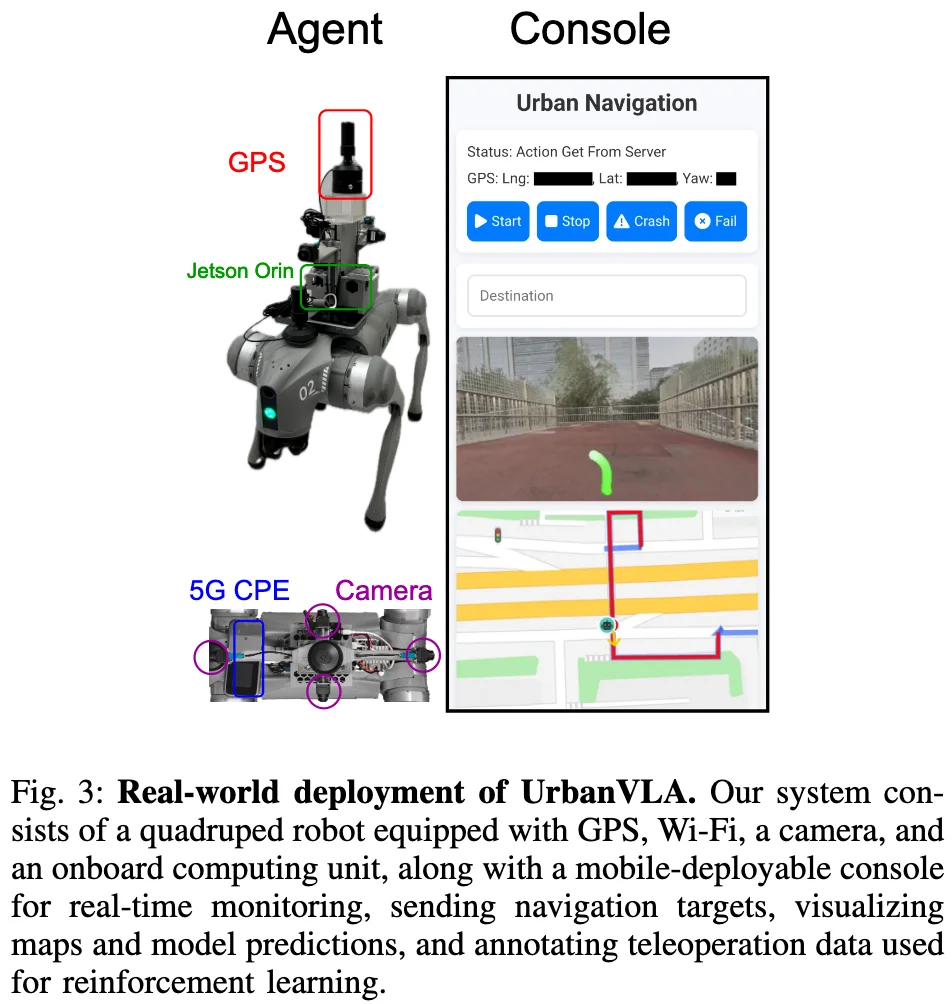
- a quadruped Unitree Go2robot
- GPS
- four cameras mounted on its front, left, right, and rear sides.
- 5G
- an onboard computing unit (Jetson Orin)
- a mobile-deployable console for real-time monitoring, sending navigation targets, visualizing maps and model predictions, and annotating teleoperation data used for reinforcement learning.
- software
- model runs on a 4090 remote server, which communicates via Web-ADK with a Unitree Go2 robot.
- The system operates at 2 Hz, which is sufficient for smooth and responsive navigation.
- High-level route instructions are obtained from Amap via its Web API, while a GNSS module provides the position and orientation of the quadruped in real time.
Experiments
8 NVIDIA H100 GPUs for approximately 12 hours.